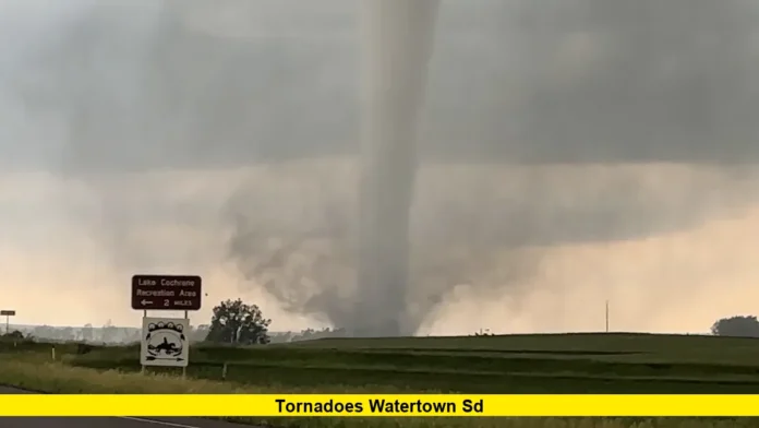
Tornadoes Watertown SD caused significant concern on Sunday evening as severe weather systems formed rapidly across northeastern South Dakota. Residents in and around the Watertown area witnessed dramatic skies, loud sirens, and rotating storm clouds as a large, potentially destructive tornado moved through rural communities just outside the city.
Emergency sirens began blaring shortly after 6:30 PM, prompting citizens to take shelter immediately. Radar-indicated rotation developed quickly, and local authorities issued warnings emphasizing immediate action. This tornado was part of a broader line of supercell storms sweeping through eastern South Dakota, sparking alerts across multiple counties.
Local residents described the atmosphere as eerily quiet before the winds picked up. Clouds turned a deep green-gray as rotation intensified overhead. The tornado, which appeared to touch down just west of Watertown, reportedly traveled east for several miles before lifting.
Table of Contents
Storm Characteristics and Tornado Path
Initial analysis suggests the tornado followed a narrow path across farmland and open fields. There were several unconfirmed reports of outbuildings and trees being damaged or completely uprooted. Fortunately, no major injuries have been reported so far.
Here are some key facts related to the storm event:
- Location: Primarily rural areas west and north of Watertown, SD
- Time of Touchdown: Approximately between 6:45 PM and 7:15 PM
- Estimated Wind Speeds: Between 85 and 110 mph (based on early observations)
- Storm Direction: Moving east-northeast at around 20 mph
- Visible Funnel: Yes, clear rotation seen from several vantage points
This marks one of the most aggressive storm threats in the region this summer. Weather conditions were ripe for tornadic activity with high humidity, warm surface temperatures, and intense upper-level wind shear.
Community Response and Safety Measures
Watertown’s emergency alert systems functioned effectively, giving residents enough time to respond. Many moved to basements or interior safe rooms, especially in mobile home communities or open rural properties.
Community centers and schools designated as storm shelters opened doors to provide refuge. Law enforcement blocked off several roads where debris or flooding was reported. Some power outages occurred in isolated areas, particularly where power lines were struck by flying branches or toppled poles.
Schools scheduled to open early for sports practices were delayed as a precaution, while county road crews prepared for cleanup efforts in the coming hours.
What to Expect Moving Forward
Meteorologists are continuing to monitor weather patterns in the region as more storms remain possible through the early hours of Monday. Though the tornado threat has subsided, risks still include:
- Large hail (up to 2 inches in diameter)
- Flash flooding from repeated thunderstorm cells
- Wind gusts exceeding 60 mph
Residents are advised to remain alert for additional warnings and review emergency safety plans with family members.
Signs of Tornadoes Residents Noted
Several residents who witnessed the storm firsthand shared observations such as:
- Rapid cloud rotation directly overhead
- Hail pelting windows shortly before the funnel appeared
- A low roaring sound, often compared to a freight train
- Sudden calmness followed by violent wind gusts
These classic signs gave some people just enough time to shelter. Rural homes equipped with weather radios benefited from early alerts, especially in areas with limited cell reception.
Damage and Recovery Efforts
While widespread destruction was avoided, minor damage reports continue to come in. These include:
- Sheds and barns damaged by winds
- Tree limbs scattered across roads
- Cars dented by hailstones
- Fences and signposts blown down
Cleanup efforts will begin after sunrise, with county officials urging people to avoid affected areas unless absolutely necessary. Utility crews are already assessing the electric grid for possible outages and prioritizing emergency zones first.
How Tornadoes Impact Small Communities
Events like these highlight the vulnerability of small communities in the Plains states. When a tornado develops near a city like Watertown, preparation time can be minimal. That’s why systems like emergency sirens, NOAA radios, and weather apps play a crucial role in safety.
Preparedness campaigns run by local agencies stress the following actions:
- Identify a safe shelter spot in your home
- Keep flashlights, batteries, and first-aid kits handy
- Don’t rely solely on mobile phones for alerts
- Move away from windows and exterior walls
Final Word
While the tornado that neared Watertown spared the city from major disaster, it was a powerful reminder of nature’s unpredictability. Local authorities acted quickly, residents responded wisely, and for now, Watertown can breathe a sigh of relief.
If you experienced this storm or want to share your story, drop a comment below. Your insight helps paint the full picture of how our communities face and overcome severe weather threats together.

