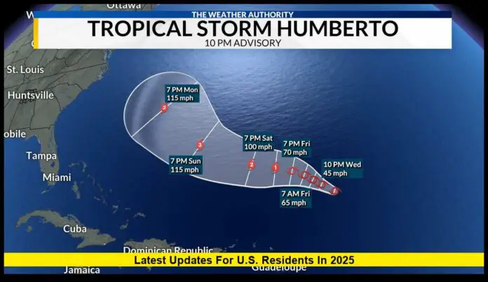
The tropical storm humberto forecast is closely watched as the Atlantic hurricane season nears its peak. As of September 25, 2025, Tropical Storm Humberto is strengthening over the Atlantic and is expected to intensify in the coming days. While the system currently poses no immediate threat of landfall in the United States, forecasters are monitoring its path closely due to potential indirect impacts along the East Coast.
Table of Contents
Current Status of Tropical Storm Humberto
Humberto is located east-northeast of the Leeward Islands and continues to move west-northwest across warm Atlantic waters. Sustained winds are near 45 mph, with higher gusts recorded in certain quadrants of the storm. Its wind field already extends outward, creating tropical-storm-force conditions well beyond its center.
At this stage, Humberto remains a tropical storm, but all signs point toward steady strengthening.
Forecast Track and Strength
The latest outlook projects Humberto will intensify steadily as it encounters favorable conditions:
- Warm ocean waters will help fuel the system.
- Low-to-moderate wind shear provides an environment for strengthening.
- Ample moisture in the mid-level atmosphere supports further development.
By the weekend, Humberto is expected to reach hurricane strength, and forecasters say it could become a major hurricane (Category 3 or higher) if conditions hold.
The track shows a gradual turn toward the north or northeast early next week, keeping the system offshore from the continental United States. However, Bermuda may be closer to the storm’s projected path, depending on how the steering currents evolve.
Possible Impacts on the U.S.
Even if Humberto stays offshore, the storm is expected to generate effects that U.S. coastal residents should prepare for:
- High surf and dangerous rip currents are likely along the East Coast, especially from Florida to the Carolinas.
- Swells generated by Humberto may reach beaches over the weekend, creating hazardous conditions for swimmers and boaters.
- Rain bands could brush outer islands or affect shipping lanes, though the U.S. mainland is not currently in the direct path.
Indirect impacts often occur with large storms that remain offshore, so caution is advised even if landfall isn’t expected.
Interaction With Other Systems
Humberto is not the only system being tracked in the Atlantic. A nearby disturbance, currently designated as a tropical wave near the Bahamas, could strengthen in the coming days. If it develops into a tropical storm, the two systems may influence each other’s movement.
This interaction could alter Humberto’s track slightly—either pulling it farther into the open Atlantic or nudging it closer to U.S. waters. While this outcome is uncertain, it highlights the importance of monitoring updates daily.
Timeline of Expected Changes
Here’s a simplified outlook for Humberto over the next several days:
| Date | Expected Development |
|---|---|
| Sept. 25–26 | Gradual strengthening into a strong tropical storm |
| Sept. 27–28 | Potential upgrade to hurricane; swells reach East Coast |
| Sept. 29–30 | Likely major hurricane offshore; closest pass near Bermuda |
| Oct. 1 onward | Storm curves northeast into cooler waters, beginning to weaken |
This timeline may shift depending on Humberto’s exact movement and interaction with surrounding systems.
What Coastal Residents Should Do
Even though Humberto’s forecast keeps the core offshore, coastal communities should not ignore the storm. Past hurricanes have shown that dangerous surf and rip currents can claim lives far from the center of circulation.
Recommended precautions include:
- Avoid swimming in rough surf or when rip current warnings are issued.
- Monitor updates from local weather offices.
- Secure outdoor items in coastal areas prone to high winds or tides.
- Mariners should plan routes carefully to avoid the storm’s expanding wind field.
Preparedness is essential during the heart of hurricane season, even when a storm’s track suggests no direct hit.
East Coast Areas to Watch
While a direct landfall is unlikely at this time, forecasters are watching several key regions:
- Florida’s East Coast: Expected to see the earliest swells and surf.
- Carolinas: High rip current risks expected by the weekend.
- Mid-Atlantic beaches: Rough surf possible early next week.
- Northeast U.S.: Less likely to see significant impacts, but minor coastal effects cannot be ruled out.
Bermuda remains the most likely land area to experience Humberto’s strongest winds and rain bands.
Why Humberto Matters
The tropical storm humberto forecast is a reminder of how quickly storms can evolve in the Atlantic. At the height of hurricane season, systems like Humberto can intensify rapidly and shift tracks unexpectedly.
For U.S. residents, the main message is clear: stay alert, even if the official path shows the storm offshore. Dangerous conditions can extend hundreds of miles from the center, and preparedness now is always better than waiting.
Final Thoughts
The answer to whether Humberto threatens the United States is complex. The tropical storm humberto forecast shows the system strengthening into a hurricane and eventually curving away from the mainland. However, dangerous surf and rip currents will still affect U.S. beaches in the coming days, making caution essential for coastal residents and visitors.
As the storm evolves, staying informed and prepared ensures safety. With several weeks left in the Atlantic hurricane season, Humberto is just the latest reminder of nature’s power and unpredictability.
How are you preparing for the rest of hurricane season? Share your thoughts and tips as communities along the coast continue to monitor Humberto’s progress.
