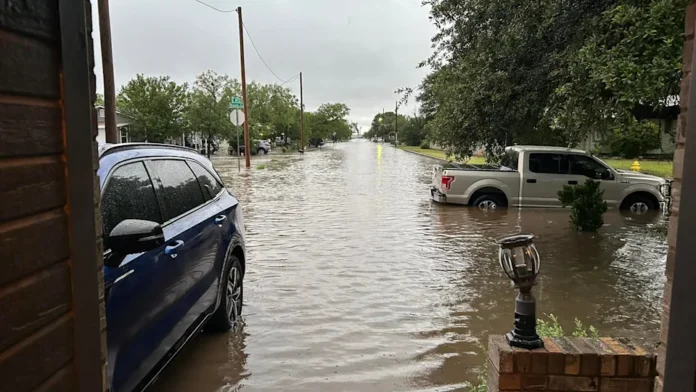
A flash flood warning has been urgently issued across large parts of Central Texas following relentless overnight storms that dumped over a foot of rain in some areas. Riverbanks are swelling, roads are submerged, and dozens of communities are on high alert as water levels continue to rise dangerously fast. The situation remains critical with authorities confirming multiple fatalities, widespread damage, and ongoing rescue efforts. The warning comes after a severe weather system parked over the region, triggering what emergency officials call an “unprecedented water surge.”
Table of Contents
Key Point Summary
- Flash flood warning issued for Central Texas after 10–15 inches of rain overnight.
- At least 25 people have died; dozens are missing, including girls from a summer camp.
- Emergency crews are conducting air and boat rescues as rivers surge.
- Roads, homes, and entire neighborhoods are flooded.
- Evacuations continue in high-risk areas.
- More rain is forecast, increasing the threat.
Emergency Rescues Underway Across Flood Zones
The most immediate impact of the flash flood warning has been the mass rescue operations. Emergency teams using helicopters, boats, and even drones are navigating flooded neighborhoods to reach those trapped in homes, cars, and buildings. In rural areas near the Guadalupe River, the situation is dire. Reports indicate that several children from a well-known summer camp remain missing after the river rose rapidly overnight. Multiple rescues have taken place on highways where motorists were caught off guard by fast-moving water.
Entire towns have been cut off as floodwaters overtook bridges and washed out roads. Emergency shelters are filling fast in communities like Burnet, Marble Falls, and Liberty Hill. Residents are being urged to leave low-lying areas immediately and not to wait for further instructions, as more rain is expected.
Flash Flood Warning Triggers Record River Surges
The Guadalupe and Colorado Rivers have surged well past flood stage, setting off alarms across county emergency offices. Officials reported river levels jumping more than 25 feet in a matter of hours, creating a lethal situation for anyone in the path. Lakes and reservoirs are overflowing, including Lake Travis, where waterfront homes are now sitting in waist-deep water.
This flash flood warning was not just a precaution—it was a necessary action as nature unleashed a deluge rarely seen in this region. Flash flood alley, known for its rapid runoff and narrow valleys, became a deadly trap for those unaware of just how quickly conditions could change.
Read also-Flash Flood Warning Strikes Central Texas: Devastation, Death Toll & Urgent Safety Updates
Understanding Why the Flash Flood Warning Was Issued
Several factors contributed to this severe event:
- A stalled storm system allowed rain to pour over the same areas for hours.
- Dry ground from previous heatwaves couldn’t absorb the water, increasing runoff.
- Local rivers and creeks, already running high, reached dangerous levels quickly.
- Thunderstorms continued training across the same path, dumping rain repeatedly.
This combination of meteorological events created perfect conditions for a flash flood emergency. The warning served as a critical lifeline, giving some time for evacuation, but many communities were still caught off guard due to the storm’s unpredictability.
What You Need to Know Now Under the Flash Flood Warning
Authorities are advising all residents in the affected regions to follow these immediate precautions:
- Avoid all flooded roadways. “Turn around, don’t drown” is more than a slogan—it’s a lifesaving directive.
- Evacuate low-lying areas, especially those near rivers, creeks, or lakes.
- Stay indoors and do not attempt to cross running water by foot or vehicle.
- Check on neighbors, particularly the elderly or those without access to alerts.
- Monitor local emergency broadcasts and sign up for mobile alerts from county officials.
Below is a quick-view table summarizing active alerts and guidance:
| County | Alert Type | Action Required |
|---|---|---|
| Kerr & Kendall | Flash Flood Warning | Evacuate flood zones |
| Travis & Burnet | Emergency Declared | Avoid roads, seek shelter |
| Williamson & Hays | Flood Watch | Prepare for worsening conditions |
Deadly Toll and Ongoing Search for Missing Individuals
Tragically, at least 25 lives have been lost, and several others remain missing as rescue teams comb through debris and swollen rivers. In one heartbreaking case, a group of young campers was swept away when floodwaters inundated their riverside cabins in the early morning hours. So far, only a few bodies have been recovered.
Officials believe more casualties may surface as waters recede. The National Guard and local fire departments are continuing to search remote areas, some only accessible by air.
Outlook: Is the Worst Over?
The forecast remains grim. Meteorologists warn of continued rainfall over the next 12–24 hours. Although totals may not reach the initial surge, the saturated ground and overwhelmed drainage systems mean even small amounts of rain could cause further flash flooding.
Communities are not out of danger yet. River levels will remain high for days. Downstream areas may begin experiencing peak flood stages as water travels from the Hill Country toward the Gulf. Residents are strongly urged to remain vigilant.
Final Thoughts
The flash flood warning currently gripping Central Texas is one of the most severe in recent memory. It has already cost lives, displaced families, and damaged property beyond recognition. While emergency crews continue their tireless efforts, the responsibility to stay safe falls on every individual. Pay attention to warnings, avoid unnecessary travel, and check in with those around you. This is a moment for unity, awareness, and action.
Stay informed, stay safe, and take flood warnings seriously—lives depend on it.

