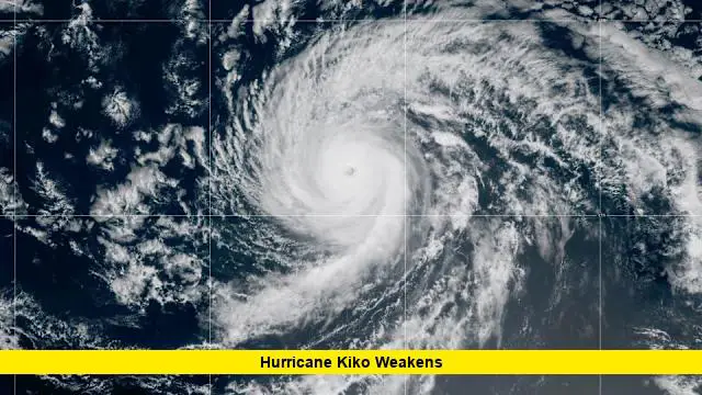
Hawaii hurricane Kiko continues to dominate headlines as the storm moves across the Pacific with changing intensity and potential impacts on the islands. As of September 7, 2025, Kiko remains a powerful system, though gradual weakening is expected in the days ahead. While the hurricane is not projected to make a direct landfall, it still poses significant threats in the form of high surf, dangerous rip currents, and possible localized flooding.
Table of Contents
Category 4 Strength and Gradual Weakening
Earlier this week, Kiko intensified rapidly, reaching Category 4 status with sustained winds near 140 miles per hour. Over the last 24 hours, the system has shown signs of weakening, with current sustained winds hovering around 130 miles per hour. The storm is moving west-northwest at about 10 miles per hour and is positioned roughly 1,000 miles east-southeast of the Big Island.
Meteorologists expect cooler ocean waters, dry upper-level air, and increasing wind shear to gradually reduce Kiko’s strength as it nears Hawaii. Forecasts suggest that the system could weaken into a lower-end hurricane or tropical storm by the time it draws closer to the islands early this coming week.
State of Emergency Declared
In anticipation of potential impacts, Hawaii’s acting governor declared a statewide state of emergency. This move ensures that resources, personnel, and supplies can be mobilized quickly if conditions worsen. The emergency order remains in effect through mid-September, covering the period in which Kiko is expected to have the most influence.
Officials urge residents to stay alert and prepare for disruptions, even if the hurricane does not make a direct landfall. Preparations include securing outdoor items, avoiding unnecessary coastal travel, and having essential supplies ready.
Coastal Impacts: Surf, Swells, and Rip Currents
Even as the system weakens, Kiko is already generating dangerous conditions along Hawaii’s coasts. East-facing shores of the Big Island and Maui are forecast to see waves between 10 and 15 feet beginning Sunday, continuing into midweek. These conditions create life-threatening rip currents and raise the risk of coastal flooding and beach erosion.
Authorities strongly advise against entering the water during this period, as rip currents will be powerful and unpredictable. Coastal roads and low-lying areas may also face flooding as swells combine with higher tides.
Forecast Timeline for Hawaii
- Sunday, Sept 7: Large swells begin to reach the Big Island and Maui. Conditions turn hazardous along east-facing beaches.
- Monday, Sept 8: Surf and rip currents intensify; isolated heavy showers possible in higher elevations.
- Tuesday–Wednesday, Sept 9–10: Closest approach of Kiko expected. Winds could reach tropical storm strength with gusts up to 70 miles per hour in some areas. Flooding is possible in mountain valleys and low-lying regions.
The exact impacts will depend on whether Kiko continues to shift northward, which would reduce direct risks to the islands, or dips slightly south, which could bring stronger winds and heavier rainfall.
Potential Hazards at a Glance
| Hazard | Details |
|---|---|
| High Surf | 10–15 foot waves on east-facing shores, leading to coastal flooding. |
| Rip Currents | Life-threatening conditions in the water; extreme caution advised. |
| Wind Gusts | Up to 70 mph possible, particularly in exposed coastal and upland areas. |
| Rainfall | Heavy, localized downpours could cause flash flooding and mudslides. |
Why Kiko is Weakening
Several environmental factors are contributing to Kiko’s decline in strength as it approaches Hawaii:
- Cooler ocean temperatures closer to the islands.
- Dry air intrusion disrupting storm circulation.
- Wind shear breaking apart the storm’s organized structure.
Even so, forecasters caution that weakening does not mean harmless. Large storms retain dangerous features such as surf, rainfall, and wind gusts, even as their categories drop.
Key Takeaways
- Hawaii hurricane Kiko remains a strong storm but is gradually weakening.
- A statewide state of emergency is in effect through mid-September.
- Dangerous surf, rip currents, and localized flooding are expected to begin Sunday.
- Winds could reach tropical storm levels by Tuesday and Wednesday during Kiko’s closest pass.
- Residents should remain cautious and continue monitoring official weather updates.
Hurricane season in Hawaii brings uncertainty with every passing system, and Kiko highlights the need for vigilance. While its strongest winds may not directly strike the islands, the storm’s impacts will still be felt, particularly along the coastlines. Stay safe, stay prepared, and share how you’re getting ready in the comments below.

