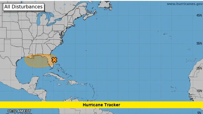
The hurricane tracker shows Invest 93‑L becoming better organized as it pushes across Central Florida today, bringing heavy rain, gusty winds, and a growing threat of flash flooding.
Early this morning, strong rainbands began sweeping through counties like Orange, Brevard, and Osceola. Rainfall totals are climbing fast, with many areas already receiving 2–4 inches. Local streets in low-lying zones are starting to flood, especially in neighborhoods near major drainage basins.
Table of Contents
Tropical System Drops Inches of Rain on Florida
Invest 93‑L is a broad low-pressure system carrying tropical moisture inland. As of this morning, it’s generating a messy pattern of thunderstorms over the central peninsula, leaving residents bracing for continued rain and localized flooding.
- 2–4 inches of rain expected across Central and East Florida
- Some regions may see up to 6 inches by tonight
- Flash flooding possible in poor drainage areas
- Winds between 20–30 mph expected during peak periods
- System is moving west, toward the Gulf of Mexico
Storm activity is expected to persist throughout the day, with embedded thunderstorms producing short bursts of heavier rainfall. Drivers are being urged to slow down and avoid waterlogged roads. Conditions will likely improve overnight as the system moves westward.
Hurricane Tracker: System Could Strengthen in the Gulf
The next major concern shown on the hurricane tracker is what happens once Invest 93‑L exits the Florida peninsula and enters the Gulf of Mexico.
Once over open water, the system is expected to encounter warm sea temperatures and relatively low wind shear—conditions favorable for tropical development. Meteorologists are closely monitoring the chance of it forming into a tropical depression or even a named storm by midweek.
Forecast models suggest the storm could drift northwest, putting parts of the northern Gulf Coast on alert by Thursday or Friday.
Gulf Coast Residents Should Stay Weather-Aware
If development continues, areas such as southeastern Louisiana, southern Mississippi, and even coastal Texas could experience several inches of rain, gusty winds, and possible flooding. While it’s too early to pinpoint the exact track or strength, emergency services are urging coastal communities to stay updated and review their preparedness plans.
This system, even without becoming a full cyclone, has the potential to cause widespread rain and travel delays across the Southeast.
Tropical Outlook for the Week Ahead
The Atlantic hurricane season remains active, and Invest 93‑L is a timely reminder of how quickly conditions can change. The system’s transition from a weak disturbance to an organized rainmaker shows how tropical weather can evolve rapidly.
Expect continued updates from national weather agencies, especially as the system reemerges over water and possibly strengthens. The hurricane tracker will remain an essential tool for watching every movement and alerting residents along the Gulf and Southeastern coasts.
Stay tuned for ongoing updates right here as we continue tracking this system’s progress. Drop your location and observations in the comments to let others know how conditions look in your area!

