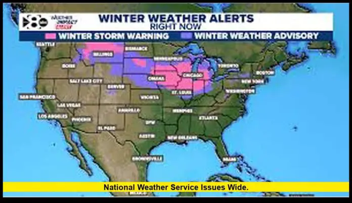
The national weather service has issued a sweeping set of winter storm warnings, advisories, and hazardous weather alerts across major regions of the United States as a strong late-season system spreads heavy snow, intense lake-effect bands, strong winds, and heavy rainfall across multiple states. With millions of Americans traveling for the holiday period, the timing of the storm is creating significant challenges for road, air, and rail transportation.
Table of Contents
A Powerful Storm System Takes Aim at the U.S.
A large winter storm strengthened over the central United States before pushing east toward the Midwest, Great Lakes, and Northeast. Forecast offices are reporting heavy accumulations of snow, rapidly declining visibility, and dangerous road conditions in several states. Areas along the southern edge of the system are seeing heavy rain and gusty winds capable of producing localized flooding.
Snow totals are expected to reach 6–12 inches in many locations, with higher amounts possible in regions that frequently experience lake-effect snow. Transportation agencies are warning drivers to expect reduced travel speeds, potential highway closures, and difficult conditions through the peak of the storm.
Where Alerts Are Active
Winter alerts span multiple regions, reflecting the diverse impacts of the storm:
- Midwest and Great Lakes: Widespread winter storm warnings and winter weather advisories are in effect. Roads may become snow-covered quickly as bands intensify.
- Upper Peninsula and Lake-Effect Regions: Snowfall rates in lake-effect zones may reach several inches per hour, creating rapidly changing conditions.
- Plains and Central States: Wet snow and strong winds are complicating travel across long stretches of interstate corridors.
- Southern States and Coastal Zones: Heavy rain and thunderstorms on the system’s southern edge may trigger localized flooding, especially in low-lying areas.
Forecast centers are urging residents and travelers to monitor local updates as conditions may shift quickly depending on temperature changes and wind direction.
Travel Disruptions and Safety Concerns
The storm’s timing poses major challenges for air and ground travel. Airports across the Midwest and Great Lakes have reported delays and cancellations due to low visibility and runway conditions. Travelers are being advised to check flight statuses frequently and allow additional time for airport procedures.
Highways are experiencing slowdowns as road crews work continuously to clear accumulating snow. Blowing snow and gusty winds are creating whiteout pockets, particularly in rural and open areas. Emergency managers recommend avoiding nonessential travel during peak snowfall.
Rail and freight operations may also be affected by drifting snow and ice, with some services adjusting schedules to reduce risks.
Regional Impact Breakdown
Great Lakes and Upper Midwest
Lake-effect snow continues to be the most intense element of this storm. Narrow but powerful snow bands are forming over the lakes, creating isolated areas of extreme accumulation. Cities downwind of the lakes should expect periods of heavy, sudden snowfall that can quickly disrupt local travel.
Central Plains
As colder air sweeps in behind the storm, wet snow is spreading across parts of the Plains. Visibility may drop sharply when snow and wind combine, making highway travel hazardous.
Northeast Corridor
Depending on temperature swings, areas in the Northeast may see a mix of rain, wet snow, and wind. Coastal and interior zones could see different impacts within short distances.
Southern U.S. and Gulf Coast
The southern portion of the storm is driving heavy rainfall and isolated thunderstorms. Flood-prone neighborhoods should remain especially alert.
How the National Weather Service Communicates Danger
The national weather service uses watches, warnings, and advisories to help communities understand the seriousness of incoming weather:
- Warnings indicate that hazardous winter conditions are either ongoing or imminent and require immediate action.
- Watches mean weather conditions are favorable for dangerous winter weather, and residents should prepare.
- Advisories signal that conditions may be less severe but still pose risks, especially to travel.
Local forecast offices expand on national guidance with pinpoint forecasts, hourly expectations, and neighborhood-level impacts that help residents make safe decisions.
What Residents Should Do Now
Officials recommend the following precautions:
- Delay nonessential travel until roads clear and visibility improves.
- Check forecasts frequently as conditions may evolve rapidly.
- Prepare vehicles with emergency supplies including blankets, chargers, snacks, and first-aid kits.
- Move outdoor items indoors or secure them in high-wind areas.
- Prepare for possible outages by charging devices and having backup lighting ready.
- Monitor flood-prone locations if you live along waterways or low-lying areas.
Emergency authorities stress that the combination of heavy snow, wind, and cold temperatures can turn otherwise simple trips into serious hazards.
Why This Storm Is Producing Such Intense Snowfall
The storm’s strength comes from a combination of cold Arctic air meeting warmer, moisture-rich air, producing favorable conditions for widespread snow. Over the Great Lakes, passing cold air flowing across warmer lake water fuels powerful lake-effect bands. These narrow corridors can deliver extreme snowfall to limited areas, raising totals far above regional averages.
Seasonal Notes: Winter Weather Ahead
The storm arrives as the nation transitions into a more active winter pattern. Climate and seasonal projections indicate that additional cold-air outbreaks and winter systems are likely in the coming weeks. Travel periods through December may see intermittent disruptions, making early preparation essential.
How Forecast Teams and Emergency Agencies Are Responding
National and local forecast centers are coordinating with state and local emergency managers, transportation departments, and airport authorities. Road crews are pretreating highways, rail operators are monitoring track conditions, and some cities are preparing warming centers in case of outages or extended road closures.
This coordination ensures communities receive timely alerts, updated hazard maps, and clear safety instructions as conditions develop.
Looking Ahead
The national weather service expects conditions to gradually improve as the storm moves east, but lingering lake-effect snow and cold temperatures will keep hazards elevated in some regions. Travelers, commuters, and residents should remain alert, follow updates, and take precautions until the system fully clears.

