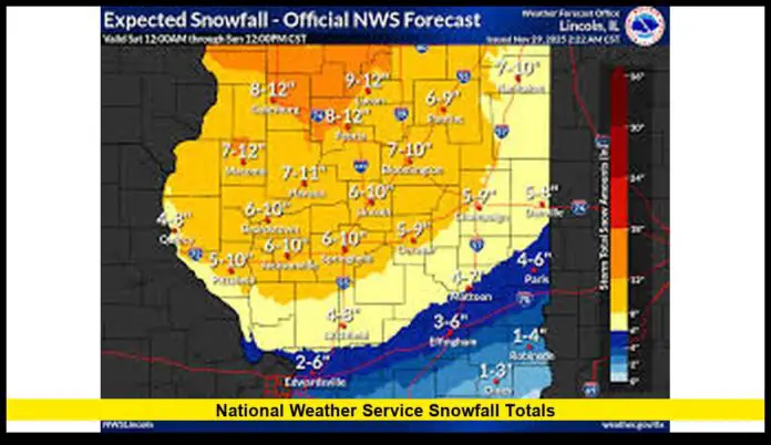
The latest verified National Weather Service snowfall totals show significant snow accumulations across parts of the U.S. as an early-season winter storm moves through the Midwest and Great Lakes region. Several locales recorded their earliest heavy snow of the season, with measurable snowfall ranging from a few inches to more than 8 inches in some zones.
Table of Contents
Snowfall Highlights from the Latest Storm
- In the Chicago region, the storm dropped widespread snowfall totals of 6 to 10 inches, with the main airport seeing 8.4 inches — the highest November daily total on record for the city.
- In parts of central Illinois, many counties reported between 3 and 8 inches of snow, with a few locally heavier amounts.
- Numerous suburbs around Chicago and northwest Indiana also picked up several inches: for example, Aurora and Clarendon Hills each logged about 7 inches, while Bradley saw roughly 6.6 inches, and areas like Bourbonnais and Bridgeport reported between 4 and 4.5 inches.
- Snowfall continued into Sunday morning in some areas, with additional flurries possible, bringing totals slightly higher in certain zones.
These confirmed snowfall totals reflect preliminary data. In some regions snow accumulation was still rising as of Sunday morning, though no further official totals had been released.
What This Means Region by Region
Chicago & Northwest Indiana
This weekend’s winter storm delivered one of the snowiest November days on record for the Chicago area. The heavy snowfall — 8.4 inches at the airport and widespread 6–10-inch totals — disrupted travel across the region. Roads were slick from fresh snow and blowing conditions. Snow removal crews worked through the night, but more snow showers overnight threatened to add another half-inch or more.
The storm caused large-scale flight cancellations, snarled holiday travel, and forced drivers to navigate treacherous roads.
Central Illinois and Northern Illinois Suburbs
Outside the city, much of central Illinois saw a general snowfall range between 3 and 8 inches. Locally heavier amounts occurred in low-lying or lake-effect prone areas. Suburban communities and smaller towns around northern Illinois recorded varying amounts: a few inches in some pockets, 6–7 inches in others.
This early-season snow is significant. It’s enough to impact road safety, delay events, and prompt local snow-removal operations.
Broader Midwest and Great Lakes Region
Although detailed totals are still pending for many areas beyond Illinois, the storm is part of a broader wave sweeping across the Great Lakes and Upper Midwest. Early warnings from the National Weather Service had anticipated snow accumulations of 6–12 inches in vulnerable zones. This storm confirms at least the lower end of those predictions — and offers a sobering preview of what early winter may bring.
Why These Snowfall Totals Matter
- Travel disruption — Tens of thousands of holiday-weekend travelers may face slick roads, white-outs, or closures. In regions where snowfall exceeded 8 inches, snow removal and road treatment will be a challenge.
- Infrastructure strain — Heavy snowfall can overload power lines, tree limbs, and drainage systems. Power outages and water-main breaks become real threats.
- Early-season snowpack — Early snowfall sets the stage for deeper snow cover this winter. For ski resorts, water resource managers, and municipalities, these early totals will affect snow-removal budgets, winter maintenance strategies, and even flood-risk planning for spring melt.
- Public safety — For communities unprepared for snow this early, the risk of accidents, stranded vehicles, or inadequate heating increases. Snowfall totals from the National Weather Service help local governments and residents stay alert and take precautions.
Looking Ahead: What to Expect
Forecasters with the National Weather Service and regional weather offices warn that additional snow is still possible in many of the affected regions — especially near the Great Lakes and in the Upper Midwest. As temperatures drop further, even light snow could stick.
Meanwhile, snow cover extent is likely to continue increasing nationwide. As snow accumulates, winter conditions may evolve rapidly — bringing more hazardous travel, frigid lows, and potential impacts to infrastructure. Residents in snow-prone areas should stay tuned for updated reports and heed any travel or weather advisories.
Snowfall totals from the National Weather Service underscore how powerful and early this season’s storms are. As more snow falls and accumulates, many parts of the country will soon contend with winter’s full effects.
Stay warm, stay aware, and feel free to share your snowfall reports — let’s keep the community informed.

