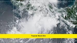
Tropical Storm Erin is at the forefront of attention as the National Hurricane Center (NHC) closely monitors multiple systems in the Atlantic with growing potential to develop into a named storm. With the peak of the hurricane season approaching, one of these disturbances could soon earn the name Erin, prompting heightened awareness among coastal communities.
Table of Contents
Current Situation & Forecast
A disturbance positioned just off the Southeast U.S. coast has been steadily gaining attention. In the past 24 hours, its development chances have risen to 10% over the next 48 hours and 40% within the next seven days. Should this system intensify, it would be named Tropical Storm Erin.
Farther east, a tropical wave off the coast of Africa is also on the NHC’s watchlist. While its short-term development chances remain low, forecasters give it a 50% chance of forming over the next week. This wave could also become Erin if the U.S. coastal system fails to develop first.
In addition, another disturbance known as Invest 97L is being monitored closely. Forecasters suggest it could become a tropical depression, or even a brief tropical storm, within the next 24 hours.
Key Points Summary
(Quick glance for readers who want the essentials)
- U.S. coastal disturbance: 10% chance in 48 hours, 40% chance in 7 days — could be named Erin.
- African tropical wave: Near 0% in 48 hours, 50% in 7 days — also a contender for the name Erin.
- Invest 97L: Possible immediate development into a depression or short-lived storm.
- No current land impacts, but forecasts can shift quickly.
Development Prospects and Risks
August is one of the most active months for Atlantic storm formation. Warm sea surface temperatures and favorable atmospheric conditions can quickly turn a weak disturbance into a tropical storm or even a hurricane.
While both the U.S. coastal disturbance and the African wave show potential, the coastal system’s proximity to warm waters and less hostile wind patterns increases its chances of rapid development. If named first, it would officially be Tropical Storm Erin.
If both systems develop, the first to reach tropical storm strength would take the Erin name, with the second moving on to the next name on the list — Fernand.
At present, no direct threats to land have been confirmed. However, forecasters warn that changing steering currents and strengthening patterns could alter paths, especially for the system near the U.S. East Coast.
Read Also-NOAA Hurricane Update: What to Expect This Season as Activity Remains Above Normal
What This Means for Coastal Areas
While it’s still too early to issue specific warnings, residents along the southeastern U.S. coastline and in parts of the Caribbean should keep an eye on updates from the NHC. The earlier a storm is detected and tracked, the better prepared communities can be to handle possible impacts such as heavy rainfall, gusty winds, and dangerous surf.
Preparedness steps may include:
- Monitoring local weather updates several times a day.
- Checking emergency supplies and hurricane kits.
- Reviewing evacuation routes in case they become necessary.
What to Watch in the Coming Days
- NHC Outlooks: Updated multiple times daily with the latest development probabilities.
- Satellite imagery: Signs of rotation or a defined low-pressure center will indicate a higher chance of naming.
- Model guidance: Tracking shifts in storm path forecasts to determine potential areas of concern.
Given the favorable conditions for tropical development in mid-August, forecasters emphasize that situations can escalate quickly.
Closing Thoughts
Multiple systems are competing for the next name on the 2025 Atlantic hurricane list, but all eyes are on the disturbance just off the Southeast U.S. coast. Whether it’s this system or the African tropical wave that earns the title Tropical Storm Erin, the message remains clear — it’s time to stay alert, informed, and ready for any changes.
If you live in a region that could be impacted, keeping a close watch on official forecasts over the next few days will be crucial. Storm season is here, and preparedness is key.

