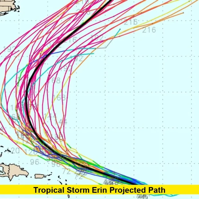
Tropical Storm Erin projected path has propelled intense interest across the Caribbean and the U.S. East Coast, with meteorologists closely watching its development this week. Erin, currently the fifth named storm of the 2025 Atlantic hurricane season, is moving west near 17mph and may rapidly intensify into the season’s first major hurricane by Friday.
Table of Contents
Erin’s Track and Path: Where Is It Heading?
Erin is now positioned just over 1,000 miles east of the northern Leeward Islands, tracing a westward course expected to veer toward the west-northwest. The main forecast models show Erin skirting north of the Virgin Islands and Puerto Rico through the weekend, unleashing heavy rain, strong winds, and dangerous surf conditions in those regions. While Erin is not predicted to make direct landfall, the storm’s effects—especially hazardous rip currents—will spread far beyond its center.
Meteorologists stress that considerable uncertainty remains in the longer-term trajectory, with the National Hurricane Center noting that possible impacts in the Bahamas, Bermuda, or along the U.S. East Coast next week are still uncertain.
⚡️ Key Points Summary ⚡️
What to Expect This Weekend
- Erin is forecasted to become a hurricane by Friday as it encounters warmer waters and low wind shear, ideal conditions for strengthening.
- Bands of rain and squally weather may hit the northern Caribbean islands, affecting travel and local activities.
- Swells and rip currents, labeled “life-threatening” by the National Hurricane Center, are likely to develop along the islands, the Bahamas, and the U.S. East coast through next week.
- Airlines have begun issuing travel waivers for flights in the Northeast, and cruise ships are rerouting to avoid the worst affected regions.
U.S. East Coast: Risk Assessment
Forecast consensus currently keeps Erin offshore, but the models have shifted the potential track a bit closer to the coast as of Thursday. Locations from Cape Hatteras to Cape Cod are under cautious scrutiny, although the worst impacts still seem likely to remain offshore. Meteorologists emphasize that errors for hurricane forecasts six days out can be 300 miles or more, so vigilance is key.
Regardless of a direct hit, powerful surf and rip currents will radiate outward from the storm, especially as Erin grows larger with potential Category 3 strength by Monday and Tuesday. Beachgoers and boaters along the Southeast to the Northeast should monitor local advisories and be prepared for hazardous conditions.
Current Watches, Warnings, and Uncertainties
- As of Thursday, there are no coastal watches or warnings, but that could change rapidly if Erin’s projected path shifts closer to land.
- Puerto Rico, the Virgin Islands, and the northern Leeward Islands remain on alert for adverse weather effects starting Friday night through the weekend.
- In Bermuda, authorities and residents are advised to stay updated, as the eventual northward turn could bring the storm closer next week.
Recent Developments and Next Steps
- Hurricane Hunters are scheduled to fly into Erin this evening to gather the latest real-time data for more accurate forecasts.
- Behind Erin, meteorologists are monitoring multiple other tropical disturbances in the Atlantic, but none are set to organize in the coming week.
As Tropical Storm Erin projected path evolves, staying informed with real-time government advisories is essential—especially for those in the affected regions. Whether you’re traveling, living, or vacationing in the Caribbean or along the East Coast, share your experiences or thoughts below, and check back for the freshest updates on Erin’s progress.

