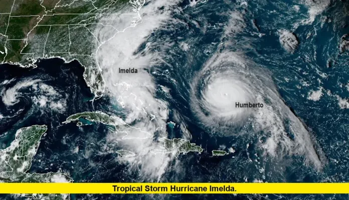
Tropical Storm Hurricane Imelda, under NOAA’s close monitoring, is drawing widespread attention as it strengthens in the Atlantic and pushes northward. The system, which began as a tropical wave in the Caribbean, has already brought heavy rainfall to parts of Puerto Rico, the Dominican Republic, and eastern Cuba. Now, NOAA forecasts indicate Imelda could reach hurricane strength while moving near the Bahamas before curving toward the open Atlantic.
Table of Contents
Current Status of Imelda
As of this morning, the storm’s center is located just southeast of the Bahamas, moving north at roughly 9 miles per hour. Maximum sustained winds have climbed past 50 miles per hour, with additional strengthening likely over the next 24 to 48 hours.
- Tropical-storm-force winds extend outward nearly 175 miles from the storm’s center.
- Rainfall totals of 4 to 8 inches are expected across the northwest Bahamas, with localized totals higher.
- Flash flooding and mudslides remain possible in mountainous areas of Cuba and Hispaniola.
While the United States is not currently forecast to receive a direct landfall, NOAA has warned that the storm’s path remains uncertain. Outer rain bands and high surf are likely to affect parts of Florida, Georgia, and the Carolinas.
How Imelda Formed
Imelda developed late last week from a tropical disturbance that gained strength over warm Caribbean waters. After dumping several inches of rain across Puerto Rico and the Dominican Republic, the system organized into a tropical storm. As it moved northward, it encountered favorable conditions for further strengthening—low wind shear, abundant tropical moisture, and sea surface temperatures near seasonal highs.
Potential U.S. Impacts
Florida
Although early forecasts showed Florida’s Atlantic coast within the possible path, recent NOAA updates suggest the storm will likely remain offshore. Still, residents are being cautioned to prepare for:
- Strong rip currents
- High surf along beaches
- Intermittent heavy rainfall in coastal areas
Carolinas and Georgia
Both North and South Carolina have taken preemptive steps by declaring states of emergency. Residents are advised to prepare for:
- 2 to 4 inches of rain in some areas
- Possible coastal flooding in low-lying communities
- Gusty winds along the shoreline
Offshore Concerns
Mariners in the Atlantic are urged to remain alert as Imelda produces rough seas and hazardous conditions for vessels.
Meteorological Factors at Play
One of the most closely watched developments is the interaction between Imelda and Hurricane Humberto, a larger storm system positioned further east in the Atlantic. Meteorologists note the possibility of the Fujiwhara Effect, where two storms can influence each other’s track. This interaction could either nudge Imelda further away from the U.S. coast or shift its trajectory closer than models currently predict.
NOAA’s Advisories and Safety Tips
NOAA emphasizes that coastal residents should not focus only on the storm’s center line. Hazards such as heavy rain, storm surge, and rip currents often extend far beyond the cone of uncertainty. Their recommendations include:
- Stay updated with the latest advisories.
- Secure outdoor objects that could become projectiles in strong winds.
- Avoid swimming or boating in rough waters.
- Prepare for localized power outages in case outer bands bring strong gusts ashore.
Outlook for the Days Ahead
Forecast models suggest Imelda will likely strengthen into a hurricane as it moves north of the Bahamas. By midweek, a turn toward the east-northeast is expected, which would steer the storm away from the mainland U.S. Even so, forecasters caution that shifts in track can occur suddenly, and coastal residents from Florida to the Carolinas should remain prepared.
Comparison of Potential Regional Impacts
| Region | Expected Hazards | Timing |
|---|---|---|
| Bahamas | Heavy rain, flooding, strong winds | Ongoing |
| Eastern Cuba | Rainfall, possible mudslides | Today into Tuesday |
| Florida Atlantic Coast | Rip currents, high surf, scattered storms | Next 24–36 hours |
| Carolinas & Georgia | Heavy rain, coastal flooding risks | Midweek |
| Offshore Waters | High seas, tropical storm conditions | Throughout the week |
Conclusion
Tropical Storm Hurricane Imelda remains a storm to watch closely. While current NOAA forecasts suggest the system will likely turn away from the U.S. coastline, outer impacts are already being felt and could intensify in the days ahead. Communities across the southeast should remain alert to updated guidance as Imelda continues its path.
How is your community preparing for this storm? Share your thoughts below and stay tuned for the latest updates.

