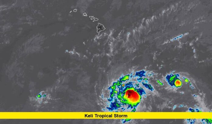
Tropical Storm Keli formed just southeast of Hawaii on July 28, becoming the second named storm of the central Pacific hurricane season. The storm is currently located over 1,000 miles southeast of Honolulu and is moving westward at around 13 miles per hour, closely following the path of the stronger Hurricane Iona.
With sustained winds near 40 mph, Keli is considered a minimal tropical storm at this stage. Meteorologists say the system remains compact, with limited growth expected in the coming days. While it may strengthen slightly before midweek, models show it gradually weakening and possibly downgrading to a tropical depression later this week.
Table of Contents
How Keli Tropical Storm Compares to Hurricane Iona
Tropical Storm Keli is forming in the wake of Hurricane Iona, which intensified into a Category 3 system earlier this week. While both storms are tracking westward across the Pacific, Keli is much weaker and significantly smaller in size.
| Key Feature | Hurricane Iona | Tropical Storm Keli |
|---|---|---|
| Max Winds | Up to 125 mph | 40 mph |
| Direction | West at 13 mph | West at 13 mph |
| Current Distance | ~765 miles SE of Honolulu | ~1,030 miles SE of Honolulu |
| Category | Major Hurricane | Tropical Storm |
| Land Threat | No | No |
Forecasts show that both systems are expected to stay well south of the Hawaiian Islands, posing no immediate danger to land. However, ocean swells from both systems may contribute to elevated surf along south- and southeast-facing shores of the islands later in the week.
Hawaii Monitoring Situation Closely
Though no watches or warnings have been issued for Hawaii, local emergency management agencies are keeping a close eye on both Keli and Iona. State and county officials have confirmed that they are ready to respond in case the forecasts change, but no major action is currently needed.
Weather experts suggest that while the systems may not directly affect the islands, they could influence Hawaii’s weather indirectly. Breezier conditions, drier air, and slightly elevated surf may be felt across the state, especially on Thursday and Friday. Additionally, a separate, unrelated southern swell is expected to arrive this week, further increasing wave activity along Hawaiian shores.
What to Expect This Week
- No land impacts are expected from Tropical Storm Keli.
- Ocean conditions may become rougher, especially on south-facing beaches.
- Humidity and air moisture may temporarily dip due to the movement of the two systems.
- Surf alerts may be issued midweek, depending on wave height.
- Forecast confidence remains high, but updates will continue daily.
Will Keli Strengthen?
Tropical Storm Keli’s small size and current environment limit its potential to grow into a major system. Experts say it may hold on to tropical storm strength for another 24–48 hours before weakening. Conditions such as increasing wind shear and less favorable ocean temperatures ahead could cause it to deteriorate quickly.
In contrast, Hurricane Iona has already reached its peak intensity and is also expected to weaken later this week as it travels westward.
Final Thoughts
At this point, both Tropical Storm Keli and Hurricane Iona are being monitored carefully by meteorological agencies, but there is no need for alarm in Hawaii. The systems are staying far offshore, with no predicted landfall or severe local impact.
Beachgoers and ocean users should remain cautious and watch for changing surf conditions. Keli, while mild, serves as a reminder that the central Pacific hurricane season is active, and island residents should stay alert to any shifting forecasts.
Stay tuned for further updates on Tropical Storm Keli and Hawaii’s evolving ocean conditions. If you’ve noticed changes in the weather or surf, drop a comment below and share your experience!
