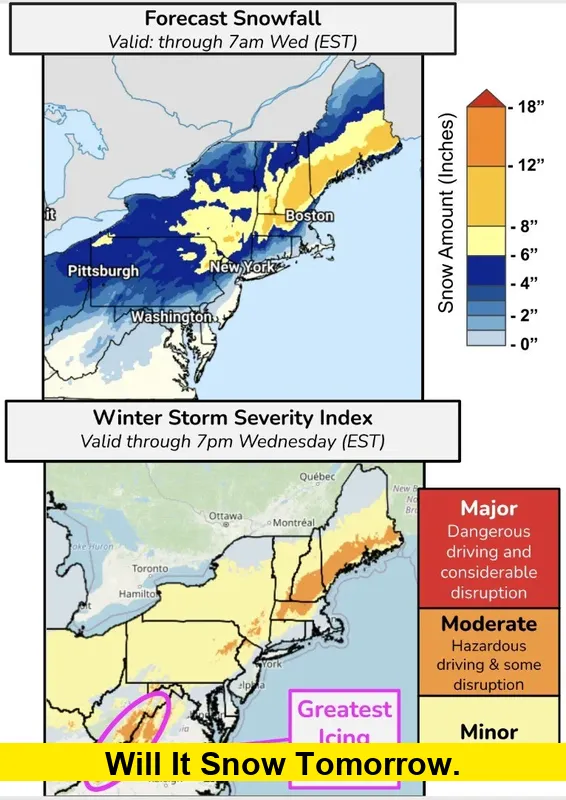
Will it snow tomorrow? Millions across the Northeast are bracing for the season’s first significant winter storm as a fast-moving system pushes into the region, bringing a mix of snow, rain, sleet, and hazardous travel impacts. With New Jersey already declaring a state of emergency for several northwestern counties, residents are gearing up for conditions that will vary sharply depending on location and elevation.
Table of Contents
State of Emergency Across Parts of New Jersey
New Jersey has activated a statewide response ahead of the storm, directing crews to pre-treat roads, prepare plows, and coordinate emergency resources. Counties in the northwestern part of the state—where colder air tends to linger—are expected to bear the brunt of accumulating snow.
Officials urged residents to avoid unnecessary travel during the height of the storm, especially early Tuesday morning. The declaration allows transportation and emergency agencies to respond more quickly as conditions change and precipitation intensifies.
Snow Totals: Where the Heaviest Accumulation Is Expected
A sharp rain-snow line will slice across the region, producing very different outcomes from one community to the next. Current projections show:
Northwest New Jersey & Higher Elevations
These areas are cold enough to support steady snowfall. Forecast totals range from 3 to 6 inches, with isolated pockets approaching 7 inches at the highest elevations. Snow is expected to stick quickly on untreated roads.
Interior Northeast & Suburban Regions
Communities just northwest of major cities—including portions of the Hudson Valley and interior New Jersey—may see 2 to 5 inches of snow before a transition to rain later in the day. Elevation will play a major role in whether snow accumulates or melts on contact.
Coastal Areas & Major Metro Zones
Cities closer to the coast, including those in eastern New Jersey, New York City, and southeastern Pennsylvania, are likely to experience mostly rain with a brief mix early Tuesday. Snowfall accumulations here are expected to be minimal or nonexistent.
Timing of the Storm
The system is expected to move in overnight and intensify during the early morning hours Tuesday. The most impactful window for commuters will be between 5 a.m. and 11 a.m., when snow, slush, and freezing precipitation are likely across inland counties.
By midday, warmer air may push into coastal and southern regions, changing snow to rain. Northern and elevated areas, however, may stay cold enough for wintry precipitation into the afternoon. Most of the storm is expected to taper off by evening.
Travel & Safety Impacts
The combination of snow, sleet, and freezing rain will create slippery conditions in multiple states across the Northeast. Even areas transitioning to rain may experience icy patches, especially on bridges, overpasses, and untreated rural roads.
Residents should prepare for:
- Reduced visibility during the morning commute
- Slushy, snow-covered, or icy roads inland
- Water buildup and slush in areas turning to rain
- Delays in public transportation and airport schedules
Road crews will continue treating surfaces throughout the event, but localized hazards may appear quickly as precipitation intensity fluctuates.
Why Forecasts Still Carry Uncertainty
This system features a narrow temperature gradient, meaning slight shifts in the storm’s track could drastically change local outcomes. A variation of just a few miles can determine whether a town receives several inches of snow or mostly rain.
Because early-season storms often involve marginal temperatures, conditions can change in a matter of hours. Residents are encouraged to monitor updated forecasts through the day and stay alert to any rapid transitions.
How to Prepare Before the Storm Arrives
- Charge phones and devices ahead of possible outages in higher-elevation areas.
- Keep shovels, ice melt, or sand ready if you live in regions expecting accumulation.
- Leave extra time for the morning commute, especially north and west of major highways.
- Park off the street where possible to allow plows clear access.
- Dress in layers if clearing snow, as temperatures will hover near freezing.
While this storm is not expected to be extreme for the entire Northeast, its mix of snow, rain, and rapid changes makes preparation essential—especially for those living in inland and elevated communities.
Share your town or ZIP code in the comments, and I’ll break down your exact snow or rain expectation for tomorrow.

